


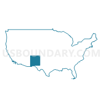
Far Southeast New Mexico PUMA, New Mexico
About
Outline

Summary
| Unique Area Identifier | 193447 |
| Name | Far Southeast New Mexico PUMA |
| State | New Mexico |
| Area (square miles) | 8,591.72 |
| Land Area (square miles) | 8,566.66 |
| Water Area (square miles) | 25.07 |
| % of Land Area | 99.71 |
| % of Water Area | 0.29 |
| Latitude of the Internal Point | 32.63536820 |
| Longtitude of the Internal Point | -103.83891410 |
Maps

Graphs
Select a template below for downloading or customizing gragh for Far Southeast New Mexico PUMA, New Mexico


Neighbors
Neighoring Public Use Microdata Area (by Name) Neighboring Public Use Microdata Area on the Map
- Central Southeast New Mexico PUMA, NM
- Eastern Plains New Mexico PUMA, NM
- Rio Grande COG & Permian Basin Regional Planning Commission (West) PUMA, TX
- South Plains Association of Governments (Outside Lubbock County) PUMA, TX
Top 10 Neighboring County (by Population) Neighboring County on the Map
- Chaves County, NM (65,645)
- Lea County, NM (64,727)
- Otero County, NM (63,797)
- Eddy County, NM (53,829)
- Roosevelt County, NM (19,846)
- Gaines County, TX (17,526)
- Andrews County, TX (14,786)
- Reeves County, TX (13,783)
- Yoakum County, TX (7,879)
- Winkler County, TX (7,110)
Top 10 Neighboring County Subdivision (by Population) Neighboring County Subdivision on the Map
- Hobbs CCD, Lea County, NM (43,305)
- Carlsbad CCD, Eddy County, NM (33,626)
- Artesia CCD, Eddy County, NM (17,725)
- Lovington CCD, Lea County, NM (14,624)
- Seminole CCD, Gaines County, TX (14,015)
- Southeast Otero CCD, Otero County, NM (13,108)
- Pecos CCD, Reeves County, TX (12,808)
- Andrews North CCD, Andrews County, TX (12,075)
- Southwest Chaves CCD, Chaves County, NM (6,901)
- Kermit CCD, Winkler County, TX (6,120)
Top 10 Neighboring Place (by Population) Neighboring Place on the Map
- Hobbs city, NM (34,122)
- Carlsbad city, NM (26,138)
- Artesia city, NM (11,301)
- Lovington city, NM (11,009)
- North Hobbs CDP, NM (5,391)
- Eunice city, NM (2,922)
- Jal city, NM (2,047)
- Loving village, NM (1,413)
- La Huerta CDP, NM (1,246)
- Atoka CDP, NM (1,077)
Top 10 Neighboring Unified School District (by Population) Neighboring Unified School District on the Map
- Roswell Independent Schools, NM (58,520)
- Alamogordo Public Schools, NM (43,326)
- Hobbs Municipal Schools, NM (43,019)
- Carlsbad Municipal Schools, NM (33,835)
- Artesia Public Schools, NM (18,220)
- Lovington Public Schools, NM (14,853)
- Andrews Independent School District, TX (14,786)
- Seminole Independent School District, TX (14,399)
- Pecos-Barstow-Toyah Independent School District, TX (13,521)
- Kermit Independent School District, TX (6,108)
Top 10 Neighboring State Legislative District Lower Chamber (by Population) Neighboring State Legislative District Lower Chamber on the Map
- State House District 83, TX (173,230)
- State House District 81, TX (159,026)
- State House District 74, TX (143,566)
- State House District 62, NM (30,322)
- State House District 54, NM (30,120)
- State House District 66, NM (29,720)
- State House District 61, NM (28,541)
- State House District 58, NM (26,928)
- State House District 55, NM (26,393)
- State House District 59, NM (25,797)
Top 10 Neighboring State Legislative District Upper Chamber (by Population) Neighboring State Legislative District Upper Chamber on the Map
- State Senate District 19, TX (766,044)
- State Senate District 31, TX (727,115)
- State Senate District 42, NM (50,650)
- State Senate District 41, NM (48,782)
- State Senate District 32, NM (46,022)
- State Senate District 34, NM (45,445)
- State Senate District 27, NM (44,424)
Top 10 Neighboring 111th Congressional District (by Population) Neighboring 111th Congressional District on the Map
- Congressional District 23, TX (847,651)
- Congressional District 11, TX (710,682)
- Congressional District 19, TX (698,137)
- Congressional District 3, NM (693,284)
- Congressional District 2, NM (663,956)
Top 10 Neighboring Census Tract (by Population) Neighboring Census Tract on the Map
- Census Tract 9.02, Otero County, NM (9,941)
- Census Tract 9502, Gaines County, TX (8,643)
- Census Tract 11, Eddy County, NM (6,556)
- Census Tract 10, Eddy County, NM (6,551)
- Census Tract 6, Lea County, NM (6,487)
- Census Tract 5.02, Lea County, NM (6,244)
- Census Tract 9502, Yoakum County, TX (5,854)
- Census Tract 3, Eddy County, NM (5,810)
- Census Tract 6, Eddy County, NM (5,430)
- Census Tract 7, Eddy County, NM (5,179)
Top 10 Neighboring 5-Digit ZIP Code Tabulation Area (by Population) Neighboring 5-Digit ZIP Code Tabulation Area on the Map
- 88240, NM (37,149)
- 88220, NM (33,725)
- 88203, NM (31,561)
- 88201, NM (25,490)
- 88210, NM (17,217)
- 79714, TX (14,786)
- 88260, NM (14,343)
- 79360, TX (13,574)
- 79323, TX (6,559)
- 88242, NM (6,141)